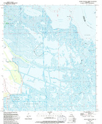
1994 Map of Golden Meadow Farms
USGS Topo · Published 1994About this map
Golden Meadow sits at the heart of this coastal landscape, where the terrestrial world gives way to an intricate network of waterways and wetlands. The map illustrates a transitional environment heavily influenced by industrial activity, most notably the extensive Oil and Gas Field operations and the Pipeline Canal that cuts across the marsh. In the south, Golden Meadow Farms and its associated Radio Tower represent the local hub, while the surrounding terrain is defined by the sinuous curves of Bayou L'Ours and West Fork Bayou Raphael.
Find a feature on this map
28 named features on this map. Tap any name to fly to it.
Don’t see what you’re looking for? This feature index may not catch every label — zoom into the map to look around manually.
Map Details
Editions of this 1994 Golden Meadow Farms Map
This is the sole edition of this map. No revisions or reprints were ever made.
Other maps of this area

1892 · Barataria
USGS Topo · 1:62,500

1892 · Cut-Off
USGS Topo · 1:62,500

1892 · Creole
USGS Topo · 1:62,500

1894 · Lake Felicity
USGS Topo · 1:62,500

1935 · Bay Courant
USGS Topo · 1:31,680

1935 · Golden Meadow
USGS Topo · 1:31,680

1935 · Mink Bayou
USGS Topo · 1:31,680

1939 · Cut-Off
USGS Topo · 1:62,500

1939 · Lake Felicity
USGS Topo · 1:62,500

1941 · Cut-Off
USGS Topo · 1:62,500