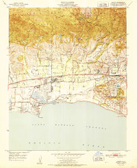
1951 Map of Goleta
USGS Topo · Published 1951About this map
The Santa Ynez Mountains rise sharply above a coastal plain where mid-century agriculture meets early suburban and institutional growth. The town of Goleta serves as the hub for this landscape, bordered by the tracks of the Southern Pacific railroad and the long stretch of Hollister Avenue. Near the shoreline, the Santa Barbara Airport occupies land adjacent to the Goleta Slough, a significant wetland area interrupted by Mescalitan Island.
Find a feature on this map
45 named features on this map. Tap any name to fly to it.
Don’t see what you’re looking for? This feature index may not catch every label — zoom into the map to look around manually.
Map Details
Editions of this 1951 Goleta Map
This is the sole edition of this map. No revisions or reprints were ever made.
Other maps of this area

1902 · Santa Ynez
USGS Topo · 1:125,000

1905 · Santa Ynez
USGS Topo · 1:125,000

1941 · San Rafael Mtn.
USGS Topo · 1:62,500

1942 · Goleta
USGS Topo · 1:62,500

1942 · San Rafael Mtn.
USGS Topo · 1:62,500

1942 · Little Pine Mountain
USGS Topo · 1:24,000

1943 · San Rafael Mtn.
USGS Topo · 1:62,500

1944 · Santa Barbara
USGS Topo · 1:31,680
1944 · Little Pine Mountain
USGS Topo · 1:31,680

1949 · Los Angeles
USGS Topo · 1:250,000