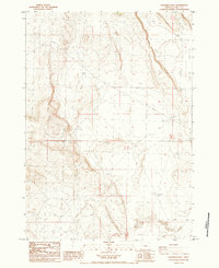
1984 Map of Goodrich Well
USGS Topo · Published 1984About this map
Butte Valley defines the high-desert character of this remote Lake County landscape, where water security dictated the pattern of human activity during the late twentieth century. This 1984 provisional survey illustrates a sparse network of essential resource points, anchored by Goodrich Well and the northern Carroll Well. The isolation of the terrain is underscored by the presence of Wagontire Road, a critical historical corridor through the sagebrush plains. Beyond the traditional grazing infrastructure, the map documents industrial and utility footprints such as Chem Nuclear Well No 1 and several extraction sites, including a Borrow Pit and Gravel Pit. These features highlight the practical land use of the era, where maintaining roads and monitoring subsurface resources were the primary drivers of regional mapping.
Find a feature on this map
11 named features on this map. Tap any name to fly to it.
Don’t see what you’re looking for? This feature index may not catch every label — zoom into the map to look around manually.
Map Details
Editions of this 1984 Goodrich Well Map
This is the sole edition of this map. No revisions or reprints were ever made.
Other maps of this area

1955 · Crescent
USGS Topo · 1:250,000

1955 · Burns
USGS Topo · 1:250,000

1957 · Crescent
USGS Topo · 1:250,000

1958 · Crescent
USGS Topo · 1:250,000

1958 · Burns
USGS Topo · 1:250,000

1959 · Burns
USGS Topo · 1:250,000

1970 · Crescent
USGS Topo · 1:250,000

1980 · Wagontire Mtn West
USGS Topo · 1:24,000

1981 · Elk Butte
USGS Topo · 1:24,000
1981 · Rams Butte
USGS Topo · 1:24,000