
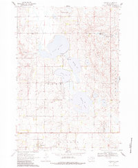
1970 Map of Goodwin
USGS Topo · Published 1972About this map
Goodwin sits at the southern edge of this landscape, a small settlement defined by its grid and proximity to the Goodwin Cem and a nearby Radio Tower. The geography is dominated by a chain of glacial depressions, including the prominent Round Lake, Bullhead Lake, and Wigdale Lake. These water bodies are surrounded by designated conservation lands such as the Round Lake State Wildlife Management Area and the Rome State Wildlife Management Area, reflecting a regional focus on habitat preservation. An Old Railroad Grade cuts through the township of Goodwin, tracing a vanished transportation corridor that once linked these prairie communities. Small details like the Roadside Park and various Gravel Pits suggest the local infrastructure of the early 1970s, while the drainage of Willow Creek connects the scattered prairie potholes and marshes.
Find a feature on this map
22 named features on this map. Tap any name to fly to it.
Don’t see what you’re looking for? This feature index may not catch every label — zoom into the map to look around manually.
Map Details
Editions of this 1970 Goodwin Map
2 editions found
Other maps of this area

1953 · Milbank
USGS Topo · 1:250,000

1953 · Watertown
USGS Topo · 1:250,000

1958 · Milbank
USGS Topo · 1:250,000

1958 · Watertown
USGS Topo · 1:250,000

1970 · Kranzburg SW
USGS Topo · 1:24,000

1970 · Kranzburg
USGS Topo · 1:24,000

1970 · Bemis
USGS Topo · 1:24,000

1973 · LaBolt
USGS Topo · 1:24,000

1973 · Tunerville
USGS Topo · 1:24,000

1973 · Stockholm
USGS Topo · 1:24,000