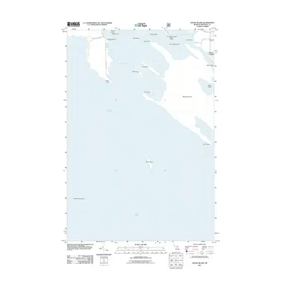
2011 Map of Goose Island
USGS Topo · Published 2011About this map
Marquette Island and the intricate archipelago of the Les Cheneaux region dominate this Lake Huron maritime survey. The landscape is defined by long, narrow peninsulas and numerous small landmasses such as Goose Island, Saint Ledger Island, and Echo Island. The complex shoreline creates sheltered waters like Wilderness Bay and Mackinac Bay, separated by landmarks such as Cube Point and Coats Point. On the mainland, Patrick Landing serves as a transition point to the water, while the Edgewood Cemetery provides a fixed point of local history near Hessel Point. This 2011 edition shows a network of local routes including W Club Rd and Point Brulee Rd that provide access to the various points and bays, documenting the modern footprint of this Michigan coastal community.
Find a feature on this map
34 named features on this map. Tap any name to fly to it.
Don’t see what you’re looking for? This feature index may not catch every label — zoom into the map to look around manually.
Map Details
Editions of this 2011 Goose Island Map
This is the sole edition of this map. No revisions or reprints were ever made.
Other maps of this area

1931 · Pickford SE
USGS Topo · 1:31,680

1932 · St Ignace NE
USGS Topo · 1:31,680

1954 · Sault Sainte Marie
USGS Topo · 1:250,000

1955 · Cheboygan
USGS Topo · 1:250,000

1956 · Sault Sainte Marie
USGS Topo · 1:250,000

1957 · Sault Sainte Marie
USGS Topo · 1:250,000

1958 · Cheboygan
USGS Topo · 1:250,000

1958 · Sault Sainte Marie
USGS Topo · 1:250,000

1964 · Round Island
USGS Topo · 1:24,000
1964 · Pickford SE
USGS Topo · 1:24,000