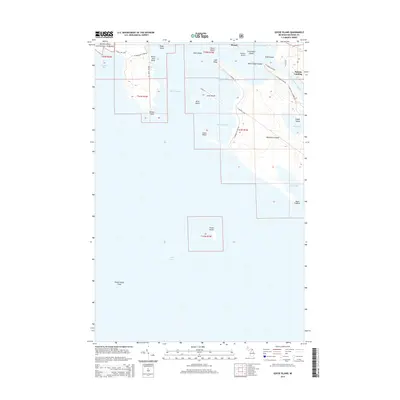
2014 Map of Goose Island
USGS Topo · Published 2014About this map
Hiawatha National Forest lands meet the northern shores of Lake Huron in this 2014 survey of the Les Cheneaux archipelago. The map documents a landscape of scattered islands and protected bays, where small landings and private roads define the coastal character. To the north, Patrick Landing serves as a focal point near the sheltered waters of Mackinac Bay and Les Cheneaux Channel. The archipelago itself is a complex network of landforms including Marquette Island, Birch Island, and the more isolated Goose Island and its namesake Goose Island Shoal to the south.
Find a feature on this map
43 named features on this map. Tap any name to fly to it.
Don’t see what you’re looking for? This feature index may not catch every label — zoom into the map to look around manually.
Map Details
Editions of this 2014 Goose Island Map
This is the sole edition of this map. No revisions or reprints were ever made.
Other maps of this area

1931 · Pickford SE
USGS Topo · 1:31,680

1932 · St Ignace NE
USGS Topo · 1:31,680

1954 · Sault Sainte Marie
USGS Topo · 1:250,000

1955 · Cheboygan
USGS Topo · 1:250,000

1956 · Sault Sainte Marie
USGS Topo · 1:250,000

1957 · Sault Sainte Marie
USGS Topo · 1:250,000

1958 · Cheboygan
USGS Topo · 1:250,000

1958 · Sault Sainte Marie
USGS Topo · 1:250,000

1964 · Round Island
USGS Topo · 1:24,000
1964 · Pickford SE
USGS Topo · 1:24,000