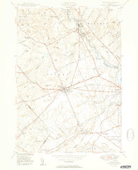
1950 Map of Gorham
USGS Topo · Published 1950About this map
Industrial and educational growth in the mid-20th century centers on the hub of Gorham, where the State Normal Sch stands at the heart of the village. The landscape is defined by the powerful flow of the Presumpscot River, which drops over Gambo Falls and Mallison Falls, powering the adjacent settlements of South Windham and Little Falls. This era shows a community in transition, balancing its agricultural roots—represented by the Windham Town Farm and Westbrook City Farm—with the vital transit networks of the Maine Central Railroad and the Boston and Maine Railroad.
Find a feature on this map
82 named features on this map. Tap any name to fly to it.
Don’t see what you’re looking for? This feature index may not catch every label — zoom into the map to look around manually.
Map Details
Editions of this 1950 Gorham Map
2 editions found
Other maps of this area

1891 · Portland
USGS Topo · 1:62,500

1891 · Buxton
USGS Topo · 1:62,500

1892 · Buxton
USGS Topo · 1:62,500

1893 · Portland
USGS Topo · 1:62,500

1893 · Buxton
USGS Topo · 1:62,500

1894 · Gray
USGS Topo · 1:62,500

1896 · Sebago
USGS Topo · 1:62,500

1898 · Gray
USGS Topo · 1:62,500

1914 · Portland
USGS Topo · 1:48,000

1916 · Portland
USGS Topo · 1:62,500