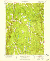
1955 Map of Goshen
USGS Topo · Published 1958About this map
The Daughters of the American Revolution State Forest dominates the high ground in the center of this 1950s survey, a landscape defined by sharp elevation changes and the numerous water bodies of the eastern Berkshires. The village of Goshen sits at a crossroads of the Berkshire Road and Main St, while the small settlement of Lithia and the town of Chesterfield anchor the western and southern quadrants. The terrain is marked by family-named hills like Mollison Hill and Walnut Hill, alongside glacial features like Bagg Ledges and the Highland Lakes. Numerous smaller water sources, such as Sears Meadow and Hammond Pond, reveal the drainage patterns feeding into the Westfield River and Swift River systems. For the local historian, the map meticulously records the locations of Goshen Cem and The Mount Cem, providing essential markers for genealogical research in this rural Massachusetts landscape.
Find a feature on this map
77 named features on this map. Tap any name to fly to it.
Don’t see what you’re looking for? This feature index may not catch every label — zoom into the map to look around manually.
Map Details
Editions of this 1955 Goshen Map
3 editions found
Other maps of this area

1885 · Northampton
USGS Topo · 1:62,500

1886 · Hawley
USGS Topo · 1:62,500

1886 · Chesterfield
USGS Topo · 1:62,500

1886 · Northampton
USGS Topo · 1:62,500

1888 · Chesterfield
USGS Topo · 1:62,500

1890 · Hawley
USGS Topo · 1:62,500

1890 · Greenfield
USGS Topo · 1:62,500

1891 · Northampton
USGS Topo · 1:62,500

1893 · Northampton
USGS Topo · 1:62,500

1893 · Chesterfield
USGS Topo · 1:62,500