
1947 Map of Goshen Pass
USGS Topo · Published 1970About this map
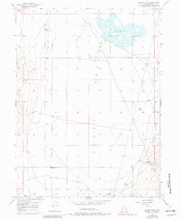
Cedar Valley dominates this high-desert landscape in the years following World War II, revealing a sparse but deliberate arrangement of water infrastructure and land management. The presence of several Well locations and a Reservoir indicates the critical importance of water rights and access in this arid region of Utah County. To the northeast, the topographic depression of the Sinks provides evidence of the area's natural drainage patterns where water terminates in the valley floor. The map highlights the narrow crossing at Goshen Pass, which serves as a vital topographic corridor between the valley and the surrounding mountain ranges. Compiled from 1943 photography with 1969 revisions, the sheet captures the transition from traditional grazing land to more modern resource extraction and water management practices in the mid-20th century.
Find a feature on this map
9 named features on this map. Tap any name to fly to it.
Don’t see what you’re looking for? This feature index may not catch every label — zoom into the map to look around manually.
Map Details
Editions of this 1947 Goshen Pass Map
2 editions found
Other maps of this area

1885 · Salt Lake
USGS Topo · 1:250,000

1885 · Tooele Valley
USGS Topo · 1:250,000

1915 · Fairfield
USGS Topo · 1:62,500

1917 · Fairfield
USGS Topo · 1:62,500

1947 · Fivemile Pass
USGS Topo · 1:62,500

1947 · Allens Ranch
USGS Topo · 1:24,000

1947 · Boulter Peak
USGS Topo · 1:24,000

1949 · Allens Ranch
USGS Topo · 1:24,000

1949 · Fivemile Pass
USGS Topo · 1:24,000

1949 · Goshen Pass
USGS Topo · 1:24,000