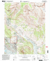
2001 Map of Gothic
USGS Topo · Published 2004About this map
Gothic stands as a focal point in this high-altitude landscape, situated at the confluence of the East River and Copper Creek. The mapping reveals a transition from the developing residential and recreational footprint at Mt Crested Butte to the preserved expanse of the Maroon Bells Snowmass Wilderness. A network of historic routes, including the Trail Riders Trail and Copper Creek Trail, navigates the complex terrain of the Elk Mountains, connecting landmarks such as Avery Peak and White Rock Mountain.
Find a feature on this map
37 named features on this map. Tap any name to fly to it.
Don’t see what you’re looking for? This feature index may not catch every label — zoom into the map to look around manually.
Map Details
Editions of this 2001 Gothic Map
This is the sole edition of this map. No revisions or reprints were ever made.
Other maps of this area

1888 · Crested Butte
USGS Topo · 1:62,500

1888 · Anthracite
USGS Topo · 1:62,500

1889 · Crested Butte
USGS Topo · 1:62,500

1889 · Anthracite
USGS Topo · 1:62,500

1893 · Anthracite
USGS Topo · 1:62,500

1893 · Crested Butte
USGS Topo · 1:62,500

1893 · Aspen
USGS Topo · 1:62,500

1894 · Anthracite
USGS Topo · 1:62,500

1895 · Aspen
USGS Topo · 1:62,500

1909 · Mount Jackson
USGS Topo · 1:125,000