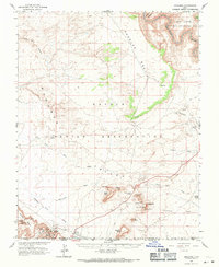
1963 Map of Goulding
USGS Topo · Published 1971About this map
Monument Valley dominates this landscape along the border of Utah and Arizona, where the high desert is punctuated by iconic formations within the Navajo Indian Reservation. At the base of Rock Door Mesa, the Goulding Trading Post and Goulding settlement represent an important outpost for local commerce and tourism, supported by a nearby Mission and Landing Strip. The map also captures several Mines in the canyons to the west, hinting at the atomic-era uranium prospecting that occurred during this mid-century period. The northern edge of the survey transitions into the Glen Canyon National Recreation Area as the terrain descends toward the San Juan River. Geological landmarks with evocative names like King on His Throne, Stagecoach, and Bear and Rabbit are carefully positioned amongst the vast drainage systems of Halgaitoh Wash and Douglas Wash.
Find a feature on this map
46 named features on this map. Tap any name to fly to it.
Don’t see what you’re looking for? This feature index may not catch every label — zoom into the map to look around manually.
Map Details
Editions of this 1963 Goulding Map
2 editions found
Other maps of this area

1883 · Marsh Pass
USGS Topo · 1:250,000

1886 · Henry Mountains
USGS Topo · 1:250,000

1886 · Abajo
USGS Topo · 1:250,000

1892 · Marsh Pass
USGS Topo · 1:250,000

1892 · Abajo
USGS Topo · 1:250,000

1892 · Henry Mountains
USGS Topo · 1:250,000

1892 · Canyon De Chelly
USGS Topo · 1:250,000

1893 · Abajo
USGS Topo · 1:250,000

1952 · Clay Hills 4 SW
USGS Topo · 1:24,000

1952 · Clay Hills 3 SE
USGS Topo · 1:24,000