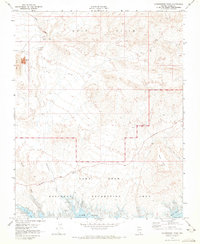
1970 Map of Government Wash
USGS Topo · Published 1973About this map
Strip Mine operations and industrial tailings dominate the northwestern landscape of this Mojave Desert survey, where extraction and recreation exist side by side. The map details the northern reaches of the Lake Mead National Recreation Area, tracing the rugged shoreline from Las Vegas Bay to the inlets of Swallow Bay. Above the waterline, the terrain is defined by the steep rises of the Gale Hills and the prominent Black Mesa, while drainage patterns like Gypsum Wash and Government Wash carve paths toward the reservoir.
Find a feature on this map
24 named features on this map. Tap any name to fly to it.
Don’t see what you’re looking for? This feature index may not catch every label — zoom into the map to look around manually.
Map Details
Editions of this 1970 Government Wash Map
This is the sole edition of this map. No revisions or reprints were ever made.
Other maps of this area

1886 · Saint Thomas
USGS Topo · 1:250,000

1893 · Saint Thomas
USGS Topo · 1:250,000

1926 · Boulder Canyon
USGS Topo · 1:96,000

1952 · Dry Lake
USGS Topo · 1:62,500

1952 · Henderson
USGS Topo · 1:62,500

1953 · Muddy Peak
USGS Topo · 1:62,500

1953 · Hoover Dam
USGS Topo · 1:62,500

1954 · Las Vegas
USGS Topo · 1:250,000

1957 · Las Vegas
USGS Topo · 1:250,000

1959 · Las Vegas
USGS Topo · 1:250,000