
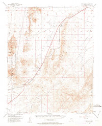
1952 Map of Dry Lake
USGS Topo · Published 1953About this map
The Union Pacific railroad and U.S. Routes 91 and 93 define the transit corridor through this arid Clark County landscape during the early 1950s. Small rail stops and settlements such as Dry Lake, Garnet, and Arrolime dot the path between the massive Arrow Canyon Range and the Muddy Mountains. The presence of the Nellis Air Force Base Bombing and Gunnery Range (Gass Peak) and the Desert Game Range Military Reservation Boundary highlights the mid-century expansion of federal military and conservation lands in southern Nevada.
Find a feature on this map
26 named features on this map. Tap any name to fly to it.
Don’t see what you’re looking for? This feature index may not catch every label — zoom into the map to look around manually.
Map Details
Editions of this 1952 Dry Lake Map
2 editions found
Other maps of this area

1886 · Saint Thomas
USGS Topo · 1:250,000

1893 · Saint Thomas
USGS Topo · 1:250,000

1907 · Las Vegas
USGS Topo · 1:250,000

1908 · Las Vegas
USGS Topo · 1:250,000

1926 · Boulder Canyon
USGS Topo · 1:96,000

1945 · Sheep Range
USGS Topo · 1:125,000

1952 · Gass Peak
USGS Topo · 1:62,500

1952 · Henderson
USGS Topo · 1:62,500

1952 · Las Vegas
USGS Topo · 1:62,500

1953 · Muddy Peak
USGS Topo · 1:62,500