1945 Map of Sheep Range
USGS Topo · Published 1945About this map
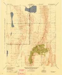
Tonopah Aerial Gunnery Range dominates the western and northern expanses of this mid-1940s landscape, reflecting the heavy military presence in the Nevada desert during the war years. Compiled from 1943 aerial photography by the U.S. Army Air Forces, the map details the Approximate Reservation Boundary slicing through the high desert. The terrain is defined by the massive verticality of the Sheep Range, culminating at Sheep Peak, and the parallel Desert Range to the west. A notable biological feature is the Yucca Forest spreading across the southern high plains, while the administrative division of the Lincoln County Clark County line establishes the political geography of this largely uninhabited territory. The absence of traditional settlements emphasizes the area's transition into a high-security military testing and training zone.
Find a feature on this map
8 named features on this map. Tap any name to fly to it.
Don’t see what you’re looking for? This feature index may not catch every label — zoom into the map to look around manually.
Map Details
Editions of this 1945 Sheep Range Map
This is the sole edition of this map. No revisions or reprints were ever made.
Other maps of this area

1885 · Pioche
USGS Topo · 1:250,000

1886 · Saint Thomas
USGS Topo · 1:250,000

1886 · Pioche
USGS Topo · 1:250,000

1893 · Saint Thomas
USGS Topo · 1:250,000

1907 · Las Vegas
USGS Topo · 1:250,000

1908 · Las Vegas
USGS Topo · 1:250,000

1926 · Boulder Canyon
USGS Topo · 1:96,000
1942 · Emigrant Valley
USGS Topo · 1:125,000

1942 · Indian Spring
USGS Topo · 1:125,000
1945 · Alamo
USGS Topo · 1:125,000