
1942 Map of Indian Spring
USGS Topo · Published 1942About this map
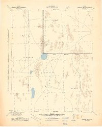
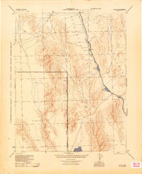
Gunnery Range operations and military designations dominate this 1942 War Department survey of southern Nevada, reflecting the region's rapid transition into a strategic defense zone during the early years of World War II. The map clearly delineates the Military Reservation Boundary cutting across the arid landscape, separating vast stretches of the Pintwater Range and Indian Spring Valley Range for military use. Settlement is sparse, centered on the small outpost of Indian Spring along the primary highway, Route 95.
Find a feature on this map
21 named features on this map. Tap any name to fly to it.
Don’t see what you’re looking for? This feature index may not catch every label — zoom into the map to look around manually.
Map Details
Editions of this 1942 Indian Spring Map
This is the sole edition of this map. No revisions or reprints were ever made.
Other maps of this area

1907 · Las Vegas
USGS Topo · 1:250,000

1908 · Kawich
USGS Topo · 1:250,000

1908 · Furnace Creek
USGS Topo · 1:250,000

1908 · Las Vegas
USGS Topo · 1:250,000

1910 · Furnace Creek
USGS Topo · 1:250,000
1942 · Emigrant Valley
USGS Topo · 1:125,000
1942 · Wheelbarrow Peak
USGS Topo · 1:125,000
1942 · Skull Mountain
USGS Topo · 1:125,000
1945 · Sheep Range
USGS Topo · 1:125,000
1945 · Alamo
USGS Topo · 1:125,000