
1886 Map of Pioche
USGS Topo · Published 1896About this map
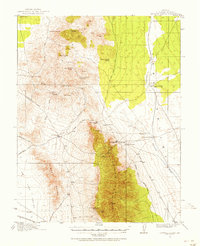
Pioche serves as the focal point of this late nineteenth-century survey, situated at the head of a complex drainage and mountain system in eastern Nevada. The map illustrates the early settlement patterns of Lincoln County, showing the proximity of the mining-era hub at Pioche to nearby Bullionville and the agricultural community of Panacca. The terrain is characterized by a series of north-south oriented ranges, including the Pahroc Mountains and the Highland Mountains, which define the broad basins of Pahroc Valley and Desert Valley. Significant water sources, such as Hackberry Spring and Coyote Spring, are noted within the Meadow Valley Mountains, highlighting the vital locations of reliable water in this arid landscape. This edition, compiled from the Powell and Wheeler surveys, captures the area before modern infrastructure, detailing the pioneer-era connections through Dry Valley and Clover Valley toward the Utah border.
Find a feature on this map
19 named features on this map. Tap any name to fly to it.
Don’t see what you’re looking for? This feature index may not catch every label — zoom into the map to look around manually.
Map Details
Editions of this 1886 Pioche Map
This is the sole edition of this map. No revisions or reprints were ever made.
Other maps of this area

1885 · St. George
USGS Topo · 1:250,000

1885 · Pioche
USGS Topo · 1:250,000

1886 · Saint Thomas
USGS Topo · 1:250,000

1886 · Mt. Trumbull
USGS Topo · 1:250,000

1891 · St. George
USGS Topo · 1:250,000

1892 · Mt. Trumbull
USGS Topo · 1:250,000

1893 · Saint Thomas
USGS Topo · 1:250,000

1907 · Las Vegas
USGS Topo · 1:250,000

1908 · Las Vegas
USGS Topo · 1:250,000
1915 · Bristol Range
USGS Topo · 1:62,500