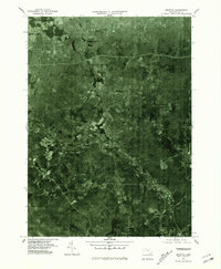
1975 Map of Grafton
USGS Topo · Published 1981About this map
Blackstone River corridors and the expanding residential patterns of central Massachusetts define this mid-1970s orthophotoquad. The imagery reveals the industrial and residential clusters of Wilkinsonville, Fisherville, and Farnumsville following the river's path, showing the density of these mill-town settlements before late-century redevelopment. To the north, the transition from the city of Worcester toward North Grafton is visible, centered around the southern reaches of Lake Quinsigamond. This aerial perspective, produced by the U.S. Geological Survey, provides a rare look at land use during a period of transition, showing the exact footprint of towns like Grafton and Northbridge through actual photographic detail rather than traditional cartographic symbols, capturing the precise layout of roads and wooded tracts as they existed in 1975.
Find a feature on this map
10 named features on this map. Tap any name to fly to it.
Don’t see what you’re looking for? This feature index may not catch every label — zoom into the map to look around manually.
Map Details
Editions of this 1975 Grafton Map
This is the sole edition of this map. No revisions or reprints were ever made.
Other maps of this area

1885 · Worcester
USGS Topo · 1:62,500

1886 · Worcester
USGS Topo · 1:62,500

1886 · Blackstone
USGS Topo · 1:62,500

1887 · Marlboro
USGS Topo · 1:62,500

1889 · Marlboro
USGS Topo · 1:62,500

1889 · Blackstone
USGS Topo · 1:62,500

1889 · Webster
USGS Topo · 1:62,500

1892 · Webster
USGS Topo · 1:62,500

1892 · Worcester
USGS Topo · 1:62,500

1893 · Blackstone
USGS Topo · 1:62,500