2023 Map of Grahamsville
USGS Topo · Published 2023About this map
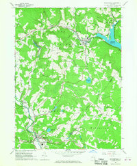
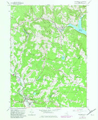
Grahamsville and Woodbourne anchor this Sullivan County landscape, where the management of water resources defines the modern geography. The presence of the Rondout Reservoir and the Neversink-Rondout Aqueduct underscores the area's role in regional infrastructure, while the East Delaware Aqueduct cuts through the northern terrain near Curry. These engineering works sit alongside traditional rural landmarks like the Grahamsville Rural Cem and the smaller Rural Cemetery to the west.
Find a feature on this map
107 named features on this map. Tap any name to fly to it.
Don’t see what you’re looking for? This feature index may not catch every label — zoom into the map to look around manually.
Map Details
Editions of this 2023 Grahamsville Map
This is the sole edition of this map. No revisions or reprints were ever made.
Historical Maps of Unionville Through Time
3 maps found