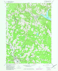
1982 Map of Grahamsville
USGS Topo · Published 1982About this map
The Rondout Reservoir dominates the northeastern corner of this Catskill landscape, illustrating the critical role of the region in New York's water infrastructure during the early 1980s. Settlements like Grahamsville and Woodbourne serve as local hubs, connected by a network of winding roads through the Catskill Park and Forest Preserve. The map details a transition between protected wilderness and developed valley floors, where the Neversink River and Beer Kill carve through the terrain. Civic landmarks such as the Woodbourne Correctional Institute and Tri Valley Sch are clearly marked, alongside genealogical points of interest like the Rural Cem. In the southern reaches, the layout of Woodbourne shows a cluster of community life around the Central Sch and local Athletic Field, providing a clear record of Sullivan County's municipal footprint before later modern expansions.
Find a feature on this map
41 named features on this map. Tap any name to fly to it.
Don’t see what you’re looking for? This feature index may not catch every label — zoom into the map to look around manually.
Map Details
Editions of this 1982 Grahamsville Map
This is the sole edition of this map. No revisions or reprints were ever made.
Other maps of this area

1903 · Slide Mountain
USGS Topo · 1:62,500

1904 · Ellenville
USGS Topo · 1:62,500

1905 · Slide Mountain
USGS Topo · 1:62,500

1906 · Ellenville
USGS Topo · 1:62,500

1909 · Monticello
USGS Topo · 1:62,500

1910 · Neversink
USGS Topo · 1:62,500

1911 · Monticello
USGS Topo · 1:62,500

1942 · Neversink
USGS Topo · 1:62,500

1942 · Lackawack
USGS Topo · 1:24,000
1942 · Ellenville
USGS Topo · 1:24,000