
1942 Map of Lackawack
USGS Topo · Published 1959About this map
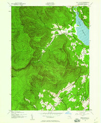
Rondout Creek carves through the Catskill foothills in this 1942 survey, revealing a landscape on the cusp of profound change. The presence of the Merriman Dam indicates the massive engineering efforts underway to create the Rondout Reservoir, a project that would soon submerged several valley settlements. Small rural centers like Lackawack and Montela are shown at their peak development before being displaced by the rising waters.
Find a feature on this map
38 named features on this map. Tap any name to fly to it.
Don’t see what you’re looking for? This feature index may not catch every label — zoom into the map to look around manually.
Map Details
Editions of this 1942 Lackawack Map
This is the sole edition of this map. No revisions or reprints were ever made.
Other maps of this area

1903 · Slide Mountain
USGS Topo · 1:62,500

1904 · Ellenville
USGS Topo · 1:62,500

1905 · Slide Mountain
USGS Topo · 1:62,500

1906 · Ellenville
USGS Topo · 1:62,500

1909 · Monticello
USGS Topo · 1:62,500

1910 · Neversink
USGS Topo · 1:62,500

1911 · Monticello
USGS Topo · 1:62,500
1942 · West Shokan
USGS Topo · 1:24,000
1942 · Neversink
USGS Topo · 1:62,500
1942 · Kerhonkson
USGS Topo · 1:24,000