1942 Map of West Shokan
USGS Topo · Published 1958About this map
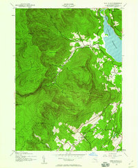
Ashokan Reservoir dominates the eastern landscape, a massive civil engineering feat that reshaped the Catskill region's topography. Based on 1942 aerial photography, this survey captures the rural layout of Ulster County before significant post-war modernization. Small mountain settlements like West Shokan and Samsonville are shown with their local schoolhouses, including the Bushkill Sch and Rochester Sch, which served as cornerstones for these isolated communities.
Find a feature on this map
45 named features on this map. Tap any name to fly to it.
Don’t see what you’re looking for? This feature index may not catch every label — zoom into the map to look around manually.
Map Details
Editions of this 1942 West Shokan Map
2 editions found

Other maps of this area

1892 · Kaaterskill
USGS Topo · 1:62,500

1893 · Kaaterskill
USGS Topo · 1:62,500

1894 · Kaaterskill
USGS Topo · 1:62,500

1899 · Kaaterskill
USGS Topo · 1:62,500

1900 · Phoenicia
USGS Topo · 1:62,500

1901 · Rosendale
USGS Topo · 1:62,500

1903 · Rosendale
USGS Topo · 1:62,500

1903 · Phoenicia
USGS Topo · 1:62,500

1903 · Kaaterskill
USGS Topo · 1:62,500

1903 · Slide Mountain
USGS Topo · 1:62,500