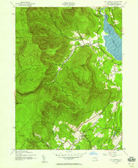
1942 Map of West Shokan
USGS Topo · Published 1960About this map
Ashokan Reservoir dominates the eastern landscape, its expansive shoreline shaping the local geography of central Ulster County. This survey, based on 1942 aerial photography, documents the high peaks of the Catskills including Cornell Mountain, Balsam Cap, and Mombaccus Mountain. The settlement pattern follows the narrow creek valleys that drain toward the reservoir, with small hamlets like West Shokan, Samsonville, and Brodhead serving as focal points for rural life. Local education is anchored by several small schoolhouses, including the Bushkill Sch and West Shokan Sch. The terrain is defined by deep hollows such as Traver Hollow Brook and Maltby Hollow Brook, while the Moonhaw Gun Club and a remote Trail system indicate the region's long-standing use for recreation and timber. These valley communities and their connecting mountain passes provide a clear look at the area's mid-century rural infrastructure before modern development.
Find a feature on this map
43 named features on this map. Tap any name to fly to it.
Don’t see what you’re looking for? This feature index may not catch every label — zoom into the map to look around manually.
Map Details
Editions of this 1942 West Shokan Map
2 editions found

Other maps of this area

1892 · Kaaterskill
USGS Topo · 1:62,500

1893 · Kaaterskill
USGS Topo · 1:62,500

1894 · Kaaterskill
USGS Topo · 1:62,500

1899 · Kaaterskill
USGS Topo · 1:62,500

1900 · Phoenicia
USGS Topo · 1:62,500

1901 · Rosendale
USGS Topo · 1:62,500

1903 · Rosendale
USGS Topo · 1:62,500

1903 · Phoenicia
USGS Topo · 1:62,500

1903 · Kaaterskill
USGS Topo · 1:62,500

1903 · Slide Mountain
USGS Topo · 1:62,500