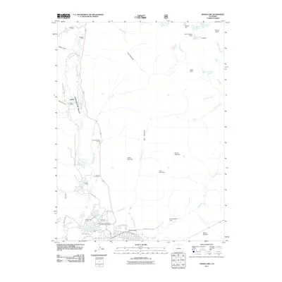
2011 Map of Grand Lake
USGS Topo · Published 2011About this map
Grand Lake serves as the focal point for this high-elevation landscape, where the Colorado River begins its course through the Kawuneeche Valley. This 2011 survey documents a region defined by alpine lakes and the historic legacy of early ranching and mining. Evidence of former settlement is found at Gaskil and its nearby Gaskill Cemetery, while family legacies are preserved at the Holzwarth Ranch and Holzwarth Cabins. The transition from early pioneer life to recreation is visible in the numerous ranches and camps, including Green Mountain Ranch and Sun Valley Ranch. The map also captures the eastern entrance to Rocky Mountain National Park, tracing the water management history through features like the Harbison Ditch and the preservation of peaks such as Mount Ida and Mount Julian.
Find a feature on this map
52 named features on this map. Tap any name to fly to it.
Don’t see what you’re looking for? This feature index may not catch every label — zoom into the map to look around manually.
Map Details
Editions of this 2011 Grand Lake Map
This is the sole edition of this map. No revisions or reprints were ever made.
Other maps of this area

1915 · Longs Peak
USGS Topo · 1:125,000

1919 · Rocky Mountain National Park
USGS Topo · 1:125,000

1954 · Greeley
USGS Topo · 1:250,000

1957 · Greeley
USGS Topo · 1:250,000

1957 · Mc Henrys Peak
USGS Topo · 1:24,000

1957 · Trail Ridge
USGS Topo · 1:24,000

1957 · Mount Richthofen
USGS Topo · 1:24,000

1957 · Bowen Mountain
USGS Topo · 1:24,000
1957 · Trail Mountain
USGS Topo · 1:24,000

1958 · Greeley
USGS Topo · 1:250,000