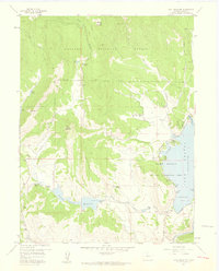
1957 Map of Trail Mountain
USGS Topo · Published 1959About this map
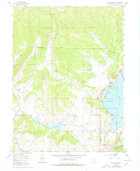
The Arapaho National Forest dominates this mid-century landscape in Grand County, where the infrastructure of the Colorado-Big Thompson Project is clearly visible. The newly created Willow Creek Reservoir and its spillway at 8130 feet are central to the map, while the western reach of Granby Lake reveals the complex shoreline of Rainbow Bay, Fish Bay, and Kokanee Cove. The map documents a transition from traditional high-country ranching to a managed recreational and water-storage landscape. Historical land use is evidenced by the Slash J Slash Ranch, Miller Hereford Ranch, and a Lumber Camp tucked near the northern forest boundary. Water management is a primary focus, shown through the Bunte Highline Ditch and Red Top Valley Ditch, which carve through the foothills of Trail Mountain and Shadow Mountain.
Find a feature on this map
39 named features on this map. Tap any name to fly to it.
Don’t see what you’re looking for? This feature index may not catch every label — zoom into the map to look around manually.
Map Details
Editions of this 1957 Trail Mountain Map
5 editions found
Other maps of this area

1915 · Longs Peak
USGS Topo · 1:125,000

1919 · Rocky Mountain National Park
USGS Topo · 1:125,000

1954 · Greeley
USGS Topo · 1:250,000

1954 · Craig
USGS Topo · 1:250,000

1956 · Radial Mountain
USGS Topo · 1:24,000

1956 · Rand
USGS Topo · 1:62,500

1957 · Craig
USGS Topo · 1:250,000

1957 · Greeley
USGS Topo · 1:250,000

1957 · Bowen Mountain
USGS Topo · 1:24,000
1957 · Granby
USGS Topo · 1:24,000