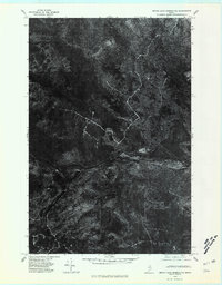
1975 Map of Grand Lake Seboeis NE
USGS Topo · Published 1981About this map
Aroostook River winds through the heart of this North Woods territory, serving as the central geographic feature in a landscape dominated by timber and wilderness in the mid-1970s. This orthophoto map provides a raw, photographic record of the terrain as it existed when the aerial imagery was captured on October 9, 1975. The settlement patterns of Oxbow are visible along the riverbanks, where the transition from cleared land to dense forest is sharp and distinct. Researchers can observe the network of logging roads and early clear-cuts that carve into the Aroostook county interior, offering an unvarnished look at the industrial and natural intersection of this remote Maine region before modern reforestation and development altered the canopy footprint.
Find a feature on this map
3 named features on this map. Tap any name to fly to it.
Don’t see what you’re looking for? This feature index may not catch every label — zoom into the map to look around manually.
Map Details
Editions of this 1975 Grand Lake Seboeis NE Map
This is the sole edition of this map. No revisions or reprints were ever made.
Other maps of this area

1930 · Greenlaw
USGS Topo · 1:48,000

1931 · Ashland
USGS Topo · 1:48,000

1933 · Greenlaw
USGS Topo · 1:62,500

1934 · Ashland
USGS Topo · 1:62,500

1940 · Oxbow
USGS Topo · 1:62,500

1942 · Oxbow
USGS Topo · 1:62,500

1953 · Ashland
USGS Topo · 1:62,500

1954 · Grand Lake Seboeis
USGS Topo · 1:62,500

1954 · Presque Isle
USGS Topo · 1:250,000

1958 · Presque Isle
USGS Topo · 1:250,000