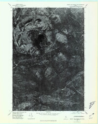
1975 Map of Grand Lake Seboeis NW
USGS Topo · Published 1981About this map
Aroostook River curves through this dense timberland in northern Maine, defining the drainage of a landscape shaped by water and elevation. Captured in 1975, the orthophoto shows the varied forest cover and logging road networks that surround Chandler Lake, a prominent water body in the northern half of the quadrangle. To the north, the terrain rises toward Mooseleuk Mountain, while the southern reaches are marked by the confluence of Mooseleuk Stream and Pomkeag Stream as they feed into the main river channel. This aerial perspective provides an unfiltered view of the woodland management patterns and natural waterways of the Maine woods during the mid-1970s, before modern satellite imagery replaced traditional orthophotography.
Find a feature on this map
5 named features on this map. Tap any name to fly to it.
Don’t see what you’re looking for? This feature index may not catch every label — zoom into the map to look around manually.
Map Details
Editions of this 1975 Grand Lake Seboeis NW Map
This is the sole edition of this map. No revisions or reprints were ever made.
Other maps of this area

1930 · Greenlaw
USGS Topo · 1:48,000

1931 · Mooseleuk Lake
USGS Topo · 1:48,000

1933 · Greenlaw
USGS Topo · 1:62,500

1935 · Mooseleuk Lake
USGS Topo · 1:62,500

1954 · Millinocket Lake
USGS Topo · 1:62,500

1954 · Grand Lake Seboeis
USGS Topo · 1:62,500

1954 · Presque Isle
USGS Topo · 1:250,000

1958 · Presque Isle
USGS Topo · 1:250,000

1960 · Presque Isle
USGS Topo · 1:250,000
1963 · Mooseleuk Lake
USGS Topo · 1:62,500