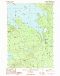
1990 Map of Grand Lake Stream
USGS Topo · Published 1990About this map
West Grand Lake dominates the northern half of this landscape, with its irregular shoreline defining the character of Grand Lake Stream Plantation. This area was documented just before the 1990s, revealing a geography shaped by timber, water, and conservation. The settlement of Grand Lake Stream serves as the focal point, situated where the waters transition toward the Grand Lake Stream State Fish Hatchery. The map captures the significant elevation changes between peaks like Wabassus Mountain and Farm Cove Mountain, and the complex hydrology of smaller bodies such as Pond Lake and Bonney Brook Lake. For local historians, the inclusion of several named landings like Bear Trap Landing and Jumbo Landing alongside Lookout Tower indicates the long-standing importance of this region for resource management and recreational transit through the Maine woods.
Find a feature on this map
59 named features on this map. Tap any name to fly to it.
Don’t see what you’re looking for? This feature index may not catch every label — zoom into the map to look around manually.
Map Details
Editions of this 1990 Grand Lake Stream Map
This is the sole edition of this map. No revisions or reprints were ever made.
Other maps of this area

1940 · Waite
USGS Topo · 1:62,500

1941 · Scraggly Lake
USGS Topo · 1:62,500

1941 · Big Lake
USGS Topo · 1:62,500

1941 · Wabassus Lake
USGS Topo · 1:62,500

1942 · Waite
USGS Topo · 1:62,500

1943 · Big Lake
USGS Topo · 1:62,500

1943 · Wabassus Lake
USGS Topo · 1:62,500

1944 · Scraggly Lake
USGS Topo · 1:62,500

1952 · Big Lake
USGS Topo · 1:50,000

1953 · Wabassus Lake
USGS Topo · 1:62,500