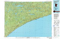
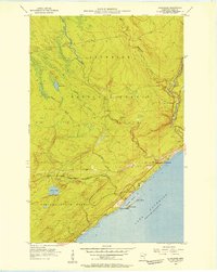
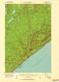
1977 Map of Grand Marais
USGS Topo · Published 1994About this map
Lake Superior defines the southern boundary of this North Shore landscape, where small settlements like Grand Marais and Lutsen cling to the coast beneath the rising elevations of the Sawtooth Bluff. This mid-1970s record illustrates a region dominated by vast public lands, including the Superior National Forest and Pat Bayle State Forest. Inland, the terrain is characterized by a dense network of glacial lakes such as Brule Lake and Greenwood Lake, and high points like Eagle Mountain within the Misquah Hills. The presence of the Grand Marais Lighthouse and the Cathedral of the Pines church reflects the local maritime and community character, while industrial features like Taconite Harbor and the Devil Track Municipal Airport highlight the infrastructure supporting the region's economy during this era.
Find a feature on this map
57 named features on this map. Tap any name to fly to it.
Don’t see what you’re looking for? This feature index may not catch every label — zoom into the map to look around manually.
Map Details
Editions of this 1977 Grand Marais Map
This is the sole edition of this map. No revisions or reprints were ever made.
Other maps of this area

1919 · Brule Lake
USGS Topo · 1:62,500
1919 · Grand Marais
USGS Topo · 1:62,500
1919 · Lutsen
USGS Topo · 1:62,500

1954 · Two Harbors
USGS Topo · 1:250,000
1955 · Tofte
USGS Topo · 1:24,000
1955 · Schroeder
USGS Topo · 1:24,000
1955 · Tofte
USGS Topo · 1:62,500
1955 · Cramer
USGS Topo · 1:62,500

1956 · Little Marais
USGS Topo · 1:24,000
1956 · Finland
USGS Topo · 1:62,500
Featured Places
- Grand Marais, MN
- Lutsen, Lutsen Township
- Tofte, Tofte Township
- Schroeder, Schroeder Township
- Lutsen Township, MN