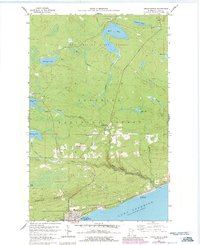
1960 Map of Grand Marais
USGS Topo · Published 1986About this map
Grand Marais and its rugged shoreline along Lake Superior anchor this mid-century topographic study. The landscape transitions sharply from the coastal settlements of Chippewa City and Croftville to the elevated terrain of Sawtooth Bluff. Inland, the map documents the rural community of Maple Hill, featuring the Maple Hill Church and Maple Hill School, alongside the regional Grand Marais-Devil Track Airport. The northern portion of the quadrangle is dominated by the dense timber of Pat Bayle State Forest and the Superior National Forest. A complex network of waterways, including Devil Track River, Mud Creek, and Binagami Lake, illustrates the drainage patterns toward the Great Lakes. Significant infrastructure of the era is present, such as the historic Gunflint Trail, a TV Relay Tower, and the local High School, providing a comprehensive view of Cook County's development during this period.
Find a feature on this map
33 named features on this map. Tap any name to fly to it.
Don’t see what you’re looking for? This feature index may not catch every label — zoom into the map to look around manually.
Map Details
Editions of this 1960 Grand Marais Map
3 editions found
Other maps of this area

1919 · Grand Marais
USGS Topo · 1:62,500

1954 · Two Harbors
USGS Topo · 1:250,000

1957 · Two Harbors
USGS Topo · 1:250,000

1958 · Two Harbors
USGS Topo · 1:250,000

1958 · Good Harbor Bay
USGS Topo · 1:24,000

1959 · Northern Light Lake
USGS Topo · 1:24,000

1959 · Pine Mountain
USGS Topo · 1:24,000

1959 · Lima Mountain
USGS Topo · 1:24,000

1960 · Grand Marais
USGS Topo · 1:24,000
1960 · Kadunce Creek
USGS Topo · 1:24,000