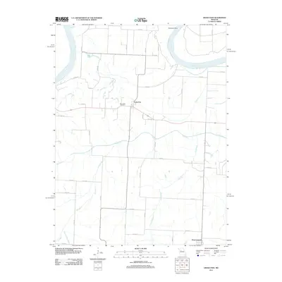
2012 Map of Grand Pass
USGS Topo · Published 2012About this map
Grand Pass occupies a central position on this Saline County landscape, situated atop the bluffs overlooking the wide floodplain of the Missouri River. The river's path is defined by the significant loop at Tamerlane Bend to the north, where old oxbows and secondary water bodies like Fish Lake indicate the historic movement of the channel. The area's agricultural character is evident in the dense network of county roads, such as Co RD-407 and Co RD-410, which connect the small settlements of Grand Pass and Mount Leonard. Beyond the river valley, the terrain is drained by several meandering waterways including the Salt Fork, Pass Branch, and the Elm Branch. Genealogists may find interest in the location of Mount Nebo Cemetery, a lone landmark positioned just west of the main settlement, preserving a quiet record of local heritage amidst the rural acreage and creek beds.
Find a feature on this map
36 named features on this map. Tap any name to fly to it.
Don’t see what you’re looking for? This feature index may not catch every label — zoom into the map to look around manually.
Map Details
Editions of this 2012 Grand Pass Map
This is the sole edition of this map. No revisions or reprints were ever made.
Other maps of this area

1889 · Lexington
USGS Topo · 1:125,000

1890 · Marshall
USGS Topo · 1:125,000

1892 · Marshall
USGS Topo · 1:125,000

1901 · Marshall
USGS Topo · 1:125,000

1951 · Alma
USGS Topo · 1:24,000

1951 · Miami Station
USGS Topo · 1:24,000

1951 · Carrollton East
USGS Topo · 1:24,000

1951 · Waverly
USGS Topo · 1:24,000

1953 · Moberly
USGS Topo · 1:250,000
1953 · Blackburn
USGS Topo · 1:24,000