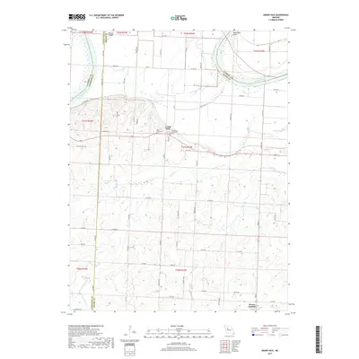
2017 Map of Grand Pass
USGS Topo · Published 2017About this map
Grand Pass and Mount Leonard anchor this portion of northern Saline County, where the landscape transitions from the sweeping curves of the Missouri River to the upland agricultural plateaus. The river's influence is evident along the northern boundary, where features like Tamerlane Bend and Whites Island define the shifting shoreline. Inland, the topography is carved by a network of drainage systems including Salt Fork and Pass Br, which flow through the fertile loess hills characteristic of this Missouri River corridor.
Find a feature on this map
55 named features on this map. Tap any name to fly to it.
Don’t see what you’re looking for? This feature index may not catch every label — zoom into the map to look around manually.
Map Details
Editions of this 2017 Grand Pass Map
This is the sole edition of this map. No revisions or reprints were ever made.
Other maps of this area

1889 · Lexington
USGS Topo · 1:125,000

1890 · Marshall
USGS Topo · 1:125,000

1892 · Marshall
USGS Topo · 1:125,000

1901 · Marshall
USGS Topo · 1:125,000

1951 · Alma
USGS Topo · 1:24,000

1951 · Miami Station
USGS Topo · 1:24,000

1951 · Carrollton East
USGS Topo · 1:24,000

1951 · Waverly
USGS Topo · 1:24,000

1953 · Moberly
USGS Topo · 1:250,000
1953 · Blackburn
USGS Topo · 1:24,000