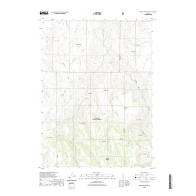
2020 Map of Grand View Peak
USGS Topo · Published 2020About this map
Sawtooth National Forest dominates this section of the Idaho high country, where the landscape is defined by a series of deep drainage basins and prominent volcanic landmarks. Grand View Peak and Wooden Shoe Butte stand as primary navigation points above the complex network of creeks that feed into the Rock Creek system. The terrain transitions from the open stretches of Sagehen Flats and Buckbrush Flats into rugged basins like Donahue Basin and Magpie Basin. This 2020 survey reveals an area heavily reliant on dispersed water sources, with named sites such as Sugarloaf Spring, Crockett Spring, and Pole Camp Spring providing critical infrastructure for cattle ranching and resource management within the national forest. Primitive tracks like Indian Spring Rd and the Electric Mud Spr trail connect these remote watering holes across the Twin Falls County and Cassia County line.
Find a feature on this map
51 named features on this map. Tap any name to fly to it.
Don’t see what you’re looking for? This feature index may not catch every label — zoom into the map to look around manually.
Map Details
Editions of this 2020 Grand View Peak Map
This is the sole edition of this map. No revisions or reprints were ever made.
Other maps of this area

1955 · Twin Falls
USGS Topo · 1:250,000

1958 · Twin Falls
USGS Topo · 1:250,000

1965 · Rams Horn Ridge
USGS Topo · 1:24,000

1965 · Stricker Butte
USGS Topo · 1:24,000

1965 · Grand View Peak
USGS Topo · 1:24,000

1965 · Hub Butte
USGS Topo · 1:24,000

1965 · Murtaugh
USGS Topo · 1:24,000

1965 · Mc Mullen Basin
USGS Topo · 1:24,000

1978 · Hopper Gulch
USGS Topo · 1:24,000
1978 · Pike Mountain
USGS Topo · 1:24,000