
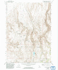
1965 Map of Mc Mullen Basin
USGS Topo · Published 1967About this map
Sawtooth National Forest dominates this mid-1960s landscape, where high ridges and deep basins define the high-country ranching and water management patterns of Twin Falls, Idaho. The area is marked by a complex network of springs and man-made water catchments, such as Dry Cottonwood Reservoir and Williams Reservoir, which were essential for sustaining livestock in the arid western terrain. These features, along with the McMullen Cow Camp and its associated Corral, underscore the long-standing cattle-grazing traditions of the McMullen Basin.
Find a feature on this map
43 named features on this map. Tap any name to fly to it.
Don’t see what you’re looking for? This feature index may not catch every label — zoom into the map to look around manually.
Map Details
Editions of this 1965 Mc Mullen Basin Map
2 editions found
Other maps of this area

1955 · Twin Falls
USGS Topo · 1:250,000

1958 · Twin Falls
USGS Topo · 1:250,000

1965 · Hollister
USGS Topo · 1:24,000

1965 · Stricker Butte
USGS Topo · 1:24,000

1965 · Berger
USGS Topo · 1:24,000

1965 · Grand View Peak
USGS Topo · 1:24,000

1965 · Hub Butte
USGS Topo · 1:24,000

1977 · Rogerson
USGS Topo · 1:24,000

1978 · Hopper Gulch
USGS Topo · 1:24,000
1978 · Pike Mountain
USGS Topo · 1:24,000