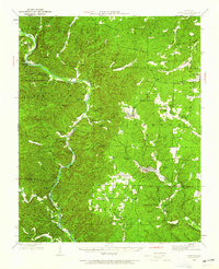
1944 Map of Grandin
USGS Topo · Published 1962About this map
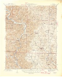
Grandin and the surrounding Ozark hills are defined here by a network of hollows and ridges during the mid-1940s. The St. Louis - San Francisco railroad cuts through the terrain, serving the local economy where sites like the Old Iron Mines point to the region's extractive history. In the western portion of the sheet, the Current River snakes through Big Spring State Park, passing Chilton and local landmarks such as Cataract Hill. This era shows a landscape transitioning from pioneer-style isolated homesteads, like McDowell Place and Old Short Place, to a more established social structure represented by numerous rural schools including White Mill Sch, Upper Tiamite Sch, and Bear Camp Sch. The abundance of small family and community burial grounds, such as Shiloh Cem and Ponder Cem, provides a detailed record for genealogical research in Carter and Ripley Counties.
Find a feature on this map
128 named features on this map. Tap any name to fly to it.
Don’t see what you’re looking for? This feature index may not catch every label — zoom into the map to look around manually.
Map Details
Editions of this 1944 Grandin Map
This is the sole edition of this map. No revisions or reprints were ever made.
Historical Maps of Ellsinore Through Time
8 maps found