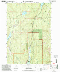
2004 Map of Granite Lake
USGS Topo · Published 2007About this map
Ponderosa State Park and the expansive Payette National Forest anchor this high-elevation landscape in central Idaho, where drainage systems from several creeks feed the North Fork Payette River. The area is defined by its significant water storage and recreational resources, including Granite Lake and the Brundage Reservoir, which sits at a specified elevation of 6218 feet.
Find a feature on this map
24 named features on this map. Tap any name to fly to it.
Don’t see what you’re looking for? This feature index may not catch every label — zoom into the map to look around manually.
Map Details
Editions of this 2004 Granite Lake Map
This is the sole edition of this map. No revisions or reprints were ever made.
Other maps of this area

1911 · Meadows
USGS Topo · 1:125,000

1938 · Riggins
USGS Topo · 1:96,000

1945 · Riggins
USGS Topo · 1:125,000

1955 · Baker
USGS Topo · 1:250,000

1955 · Grangeville
USGS Topo · 1:250,000

1956 · Elk City
USGS Topo · 1:250,000

1957 · Challis
USGS Topo · 1:250,000

1959 · Baker
USGS Topo · 1:250,000

1959 · Grangeville
USGS Topo · 1:250,000

1960 · Elk City
USGS Topo · 1:250,000