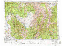
1959 Map of Grangeville
USGS Topo · Published 1959About this map
Grangeville and the high peaks of the Wallowa Mountains define this mid-century survey of the rugged borderlands between Idaho and Oregon. The landscape is dominated by vertical relief, from the deep canyons of the Snake River and Salmon River to the alpine summits of Eagle Cap and the Matterhorn. Settlement is concentrated in the fertile valleys where towns like Enterprise, Union, and Elgin are linked by the Union Pacific RR. The map illustrates a region of massive national forests, including the Wallowa National Forest and Nez Perce National Forest, where few roads penetrate. This 1950s record provides a clear look at the transportation network before modern highway expansions, showing smaller communities such as Freedom and Floral alongside significant water bodies like Wallowa Lake and Tolo Lake.
Find a feature on this map
100 named features on this map. Tap any name to fly to it.
Don’t see what you’re looking for? This feature index may not catch every label — zoom into the map to look around manually.
Map Details
Editions of this 1959 Grangeville Map
2 editions found

Historical Maps of Grangeville Through Time
3 maps found