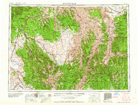
1959 Map of Grangeville
USGS Topo · Published 1959About this map
The Wallowa Mountains dominate this mid-century landscape, where high peaks like Mount Moriah and Mount Haber tower over a network of deep river canyons. The survey illustrates a region defined by its topography, from the deep gorge of the Snake River to the glacial waters of Wallowa Lake. Human settlement is concentrated in the fertile valleys, where the Union Pacific railroad connects towns such as Wallowa, Enterprise, and Elgin. Smaller, more isolated communities like Freedom and White Bird are found near the Salmon River, reflecting the early 20th-century reliance on river access and wagon roads. The map also captures several national forests, including the Nezperce National Forest and Umatilla National Forest, highlighting the vast stretches of timber and wilderness that surround the agricultural outposts of Grangeville and Union.
Find a feature on this map
169 named features on this map. Tap any name to fly to it.
Don’t see what you’re looking for? This feature index may not catch every label — zoom into the map to look around manually.
Map Details
Editions of this 1959 Grangeville Map
2 editions found

Other maps of this area

1901 · Baker City
USGS Topo · 1:125,000

1901 · Sumpter
USGS Topo · 1:125,000

1906 · Telocaset
USGS Topo · 1:125,000

1911 · Meadows
USGS Topo · 1:125,000

1915 · Pine
USGS Topo · 1:125,000

1919 · Walla Walla
USGS Topo · 1:125,000

1920 · Seven Devils Mining District
USGS Topo · 1:48,000

1921 · Walla Walla
USGS Topo · 1:125,000

1922 · He Devil
USGS Topo · 1:48,000

1924 · Kamiah
USGS Topo · 1:125,000