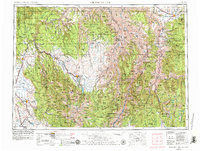
1955 Map of Grangeville
USGS Topo · Published 1979About this map
Hells Canyon National Recreation Area and the Snake River dominate the central landscape of this regional survey, marking the deep divide between the high plateaus of Oregon and Idaho. To the west, the Wallowa Mountains rise sharply, anchored by peaks like Eagle Cap and Matterhorn, while the Grande Ronde Valley supports a cluster of agricultural settlements including Elgin and Union. The Union Pacific railroad corridor threads through the southwestern corner, connecting the valley towns to the broader Pacific Northwest trade network.
Find a feature on this map
140 named features on this map. Tap any name to fly to it.
Don’t see what you’re looking for? This feature index may not catch every label — zoom into the map to look around manually.
Map Details
Editions of this 1955 Grangeville Map
4 editions found

Other maps of this area

1901 · Baker City
USGS Topo · 1:125,000

1901 · Sumpter
USGS Topo · 1:125,000

1906 · Telocaset
USGS Topo · 1:125,000

1911 · Meadows
USGS Topo · 1:125,000

1915 · Pine
USGS Topo · 1:125,000

1919 · Walla Walla
USGS Topo · 1:125,000

1920 · Seven Devils Mining District
USGS Topo · 1:48,000

1921 · Walla Walla
USGS Topo · 1:125,000

1922 · He Devil
USGS Topo · 1:48,000

1924 · Kamiah
USGS Topo · 1:125,000