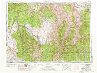
1955 Map of Grangeville
USGS Topo · Published 1976About this map
Grangeville sits at the northern edge of this mid-century survey, a vital hub where the Camas Prairie meets the rugged canyons of the Salmon River. The landscape is dominated by the massive convergence of the Snake River and its major tributaries, including the Grande Ronde River and the Imnaha River, carving deep paths through the Wallowa National Forest and Payette National Forest. This era shows a region defined by its timber and transit, where the Union Pacific and the Oregon-Washington RR & Navigation Co railroads thread through mountain passes to reach isolated settlements like Enterprise and Joseph.
Find a feature on this map
56 named features on this map. Tap any name to fly to it.
Don’t see what you’re looking for? This feature index may not catch every label — zoom into the map to look around manually.
Map Details
Editions of this 1955 Grangeville Map
4 editions found

Other maps of this area

1901 · Baker City
USGS Topo · 1:125,000

1901 · Sumpter
USGS Topo · 1:125,000

1906 · Telocaset
USGS Topo · 1:125,000

1911 · Meadows
USGS Topo · 1:125,000

1915 · Pine
USGS Topo · 1:125,000

1919 · Walla Walla
USGS Topo · 1:125,000

1920 · Seven Devils Mining District
USGS Topo · 1:48,000

1921 · Walla Walla
USGS Topo · 1:125,000

1922 · He Devil
USGS Topo · 1:48,000

1924 · Kamiah
USGS Topo · 1:125,000