1980 Map of Grangeville
USGS Topo · Published 1980About this map
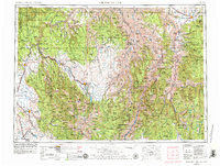
Camas Prairie provides a fertile high-plateau backdrop for the city of Grangeville, which serves as a regional hub for the surrounding ranching and timber lands. To the west, the landscape drops precipitously into the dramatic canyon of the Snake River and the Hells Canyon wilderness, while the Salmon River cuts through the center of the sheet, followed by Highway 95. This 1980 survey captures a region defined by its extreme verticality, transitioning from the level agricultural fields near Fenn and Denver to the remote mining sites of the Nez Perce National Forest. Genealogists and local historians can trace legacy sites such as the Dewey Mine, McKinley Mine, and the high-elevation settlement of Florence. The presence of the Burlington Northern railroad near the northern edge highlights the logistics of moving grain and timber out of the prairie before the terrain becomes impassable to the south.
Find a feature on this map
159 named features on this map. Tap any name to fly to it.
Don’t see what you’re looking for? This feature index may not catch every label — zoom into the map to look around manually.
Map Details
Editions of this 1980 Grangeville Map
This is the sole edition of this map. No revisions or reprints were ever made.
Historical Maps of Grangeville Through Time
3 maps found