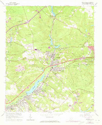
1971 Map of Graniteville
USGS Topo · Published 1971About this map
Industrial and residential development along the Horse Creek valley defines this mid-century landscape in Aiken County. The area is anchored by several interconnected mill towns, including Graniteville, Vaucluse, and Langley, where the presence of the Southern Railway and various water bodies like Langley Pond facilitated textile manufacturing and local commerce. The map documents numerous family and community landmarks, such as Graniteville Cemetery and Williams Cemetery, alongside social centers like Gregg Park and the Pine Log Community House. Extractive industries are visible through several scattered Claypit labels and a Quarry, while the educational landscape is represented by the Langleys-Bath-Clearwater High School. Recent revisions marked in purple reflect the ongoing expansion of neighborhoods like Midland Valley and the placement of new infrastructure like the Aiken Sewage Disposal facility.
Find a feature on this map
72 named features on this map. Tap any name to fly to it.
Don’t see what you’re looking for? This feature index may not catch every label — zoom into the map to look around manually.
Map Details
Editions of this 1971 Graniteville Map
This is the sole edition of this map. No revisions or reprints were ever made.
Other maps of this area

1920 · Aiken
USGS Topo · 1:48,000

1920 · Talatha
USGS Topo · 1:48,000

1921 · Augusta
USGS Topo · 1:62,500

1921 · Aiken
USGS Topo · 1:62,500

1921 · Talatha
USGS Topo · 1:62,500

1923 · Warrenville
USGS Topo · 1:48,000

1928 · Warrenville
USGS Topo · 1:62,500

1943 · Aiken
USGS Topo · 1:62,500

1943 · Augusta East
USGS Topo · 1:125,000

1943 · Warrenville
USGS Topo · 1:62,500