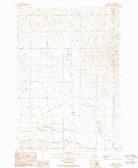
1988 Map of Grant
USGS Topo · Published 1989About this map
Horse Prairie Creek meanders through the heart of this high-elevation Montana landscape, serving as the primary drainage for the surrounding terrain. The small settlement of Grant stands at the southern edge of the valley, near the confluence with Barrett Creek. This late-twentieth-century study reveals an intricate network of irrigation systems necessary for high-plains ranching, including the Mansfield Prohosky Ditch, Cross Ranch Ditch, and the Hans Jagger Peterson Ditch. These named waterworks indicate family-managed ranching operations that have shaped the land south of the Rocky Hills.
Find a feature on this map
21 named features on this map. Tap any name to fly to it.
Don’t see what you’re looking for? This feature index may not catch every label — zoom into the map to look around manually.
Map Details
Editions of this 1988 Grant Map
This is the sole edition of this map. No revisions or reprints were ever made.
Other maps of this area

1893 · Dillon
USGS Topo · 1:250,000

1952 · Bannack
USGS Topo · 1:24,000

1952 · Eli Spring
USGS Topo · 1:24,000

1955 · Dubois
USGS Topo · 1:250,000

1955 · Dillon
USGS Topo · 1:250,000

1957 · Dillon
USGS Topo · 1:250,000

1958 · Dubois
USGS Topo · 1:250,000

1958 · Dillon
USGS Topo · 1:250,000

1959 · Grant
USGS Topo · 1:62,500

1962 · Dillon
USGS Topo · 1:250,000