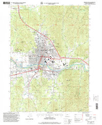
1996 Map of Grants Pass
USGS Topo · Published 1999About this map
The Rogue River defines the central corridor of Grants Pass in the mid-1990s, where urban development meets the steep slopes of the Klamath Mountains. The landscape is a mix of civic infrastructure and historic extraction, with the Forest Supervisor's Office and Hospital situated near the city center, while the outskirts are marked by numerous mining operations like the Granite Hill Mine, Ida Mine, and Jewett Mine. The map reveals a community deeply integrated with its topography, from the residential areas climbing toward Dollar Mountain to the recreational spaces of Cathedral Hills Park. Transportation and utility networks are prominent, including the South Main Canal and several communication towers, reflecting the town's role as a regional hub. Local cultural landmarks like the County Fairgrounds and a Drive-In Theater illustrate the social layout of the area during this period of growth.
Find a feature on this map
52 named features on this map. Tap any name to fly to it.
Don’t see what you’re looking for? This feature index may not catch every label — zoom into the map to look around manually.
Map Details
Editions of this 1996 Grants Pass Map
This is the sole edition of this map. No revisions or reprints were ever made.
Other maps of this area

1904 · Riddle
USGS Topo · 1:125,000

1908 · Grants Pass
USGS Topo · 1:125,000

1954 · Glendale
USGS Topo · 1:62,500

1954 · Gold Hill
USGS Topo · 1:62,500

1954 · Wimer
USGS Topo · 1:62,500

1954 · Grants Pass
USGS Topo · 1:62,500

1955 · Medford
USGS Topo · 1:250,000

1957 · Medford
USGS Topo · 1:250,000

1958 · Medford
USGS Topo · 1:250,000

1974 · Grants Pass NW
USGS Topo · 1:24,000