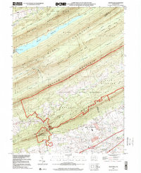
1999 Map of Grantville
USGS Topo · Published 2001About this map
Peters Mountain and a series of parallel ridges dominate this late-twentieth-century landscape, defined by the heavy presence of the Indiantown Gap Military Reservation and sprawling state-managed lands. In the south, the village of Grantville sits near the Penn National Race Course and a golf course, marking the transition from agricultural valley floor to the steep, wooded slopes of the Blue Mountain range. The ridges are separated by deep valleys carved by Stony Creek and Clark Creek, with the large De Hart Reservoir filling the gap between Peters and Rush Mountain.
Find a feature on this map
36 named features on this map. Tap any name to fly to it.
Don’t see what you’re looking for? This feature index may not catch every label — zoom into the map to look around manually.
Map Details
Editions of this 1999 Grantville Map
This is the sole edition of this map. No revisions or reprints were ever made.
Other maps of this area

1892 · Lykens
USGS Topo · 1:62,500

1892 · Hummelstown
USGS Topo · 1:62,500

1892 · Harrisburg
USGS Topo · 1:62,500

1893 · Lykens
USGS Topo · 1:62,500

1893 · Millersburg
USGS Topo · 1:62,500

1899 · Harrisburg
USGS Topo · 1:62,500

1924 · Hummelstown
USGS Topo · 1:62,500

1924 · Harrisburg
USGS Topo · 1:62,500

1943 · Millersburg
USGS Topo · 1:62,500

1943 · Lykens
USGS Topo · 1:62,500
Featured Places
- East Hanover Township, PA
- Jefferson Township, PA
- West Hanover Township, PA
- Union Township, PA
- Manada Gap, East Hanover Township