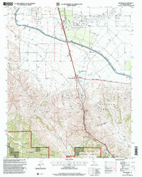
1995 Map of Grapevine
USGS Topo · Published 2000About this map
Grapevine serves as the focal point of this mid-1990s survey, where the valley floor meets the steep ascent of the San Emigdio Mountains. This corridor is defined by massive infrastructure and transit history, from the Rose Stage Station Historical Marker to the modern engineering of the Governor Edmund G Brown California Aqueduct. The landscape transitions from the agricultural and industrial activity of the Tejon Oil Field and Tejon Ag Airport in the north to the protected lands of the Los Padres National Forest in the south. The rugged geography of Grapevine Canyon is punctuated by safety and utility features like a Runaway Truck Ramp and a Pumping Station, illustrating the logistical challenges of this vital mountain pass. Historical land divisions remain visible through the boundaries of the Castaic Grant and the preservation of Fort Tejon State Historic Park near the southern edge of the sheet.
Find a feature on this map
29 named features on this map. Tap any name to fly to it.
Don’t see what you’re looking for? This feature index may not catch every label — zoom into the map to look around manually.
Map Details
Editions of this 1995 Grapevine Map
This is the sole edition of this map. No revisions or reprints were ever made.
Other maps of this area

1903 · Mt. Pinos
USGS Topo · 1:125,000

1903 · Tejon
USGS Topo · 1:125,000

1910 · Buena Vista Lake
USGS Topo · 1:125,000

1912 · Buena Vista Lake
USGS Topo · 1:125,000

1914 · Caliente
USGS Topo · 1:125,000

1931 · West of Tejon Hills
USGS Topo · 1:31,680

1931 · Tejon Hills
USGS Topo · 1:31,680

1933 · Tejon Hills
USGS Topo · 1:31,680
1934 · West of Tejon Hills
USGS Topo · 1:31,680
1934 · Coal Oil Canyon
USGS Topo · 1:31,680