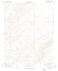
1974 Map of Grapevine Spring
USGS Topo · Published 1977About this map
Harris Springs Canyon and Lucky Strike Canyon define the high desert topography of this region within Clark County, Nevada. The 1974 field survey reveals a landscape shaped by both natural drainage and industrial exploration, evidenced by Open Pit Mines and several Prospects located in the southern reaches of the quadrangle. These sites suggest a period of active mineral interest near the head of Deer Pasture. Water sources in this arid environment are sparse but critical, marked by Grapevine Spring and Grassy Spring. Access throughout the canyons is limited to a network of a Jeep Trail, illustrating the remote and difficult nature of the terrain during the mid-1970s. The map captures the area before modern expansion, focusing on the drainage patterns of Grapevine Canyon and Goodwater Canyon.
Find a feature on this map
11 named features on this map. Tap any name to fly to it.
Don’t see what you’re looking for? This feature index may not catch every label — zoom into the map to look around manually.
Map Details
Editions of this 1974 Grapevine Spring Map
This is the sole edition of this map. No revisions or reprints were ever made.
Other maps of this area

1907 · Las Vegas
USGS Topo · 1:250,000

1908 · Las Vegas
USGS Topo · 1:250,000

1952 · Corn Creek Springs
USGS Topo · 1:62,500

1952 · Blue Diamond
USGS Topo · 1:62,500

1954 · Las Vegas
USGS Topo · 1:250,000

1957 · Las Vegas
USGS Topo · 1:250,000

1957 · Charleston Peak
USGS Topo · 1:62,500

1957 · Mountain Springs
USGS Topo · 1:62,500

1959 · Las Vegas
USGS Topo · 1:250,000

1962 · Las Vegas
USGS Topo · 1:250,000