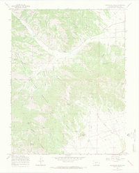
1967 Map of Graveyard Gulch
USGS Topo · Published 1970About this map
Mining history and high-altitude terrain define this 1967 survey of the Rio Grande National Forest in Saguache County. The landscape is marked by the legacy of extraction, notably at the Pershing Mine and the P E D Mine, alongside several prospect sites and a Sand Mine. The historic settlement of Parkville (Site) appears as a relic of earlier development along Kerber Creek, while Whites Cem offers a primary point of interest for genealogists researching the families who once worked these gulches.
Find a feature on this map
51 named features on this map. Tap any name to fly to it.
Don’t see what you’re looking for? This feature index may not catch every label — zoom into the map to look around manually.
Map Details
Editions of this 1967 Graveyard Gulch Map
3 editions found
Other maps of this area

1954 · Pueblo
USGS Topo · 1:250,000

1956 · Montrose
USGS Topo · 1:250,000

1957 · Pueblo
USGS Topo · 1:250,000

1958 · Pueblo
USGS Topo · 1:250,000

1959 · Montrose
USGS Topo · 1:250,000

1959 · Bonanza
USGS Topo · 1:62,500

1959 · Howard
USGS Topo · 1:62,500

1960 · Montrose
USGS Topo · 1:250,000

1962 · Pueblo
USGS Topo · 1:250,000

1966 · Pueblo
USGS Topo · 1:250,000