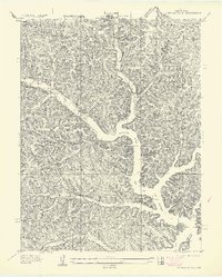
1957 Map of Gravois Mills
USGS Topo · Published 1957About this map
Gravois Arm Lake of the Ozarks dominates the central topography of this mid-century Missouri survey, showing the complex fingers and inlets of the reservoir. Surveyed in 1935 but published as an advance sheet in 1957, the map captures the rural landscape of Morgan County before extensive modern development. Educational and recreational life is centered at the Hale Sch and the YMCA Camp located near the northern edge of the sheet. The terrain is defined by a dense network of drainages including Little Gravois Creek, N Brushy Cr, and Hibbard Creek, which feed into the primary waterway. Landforms like Washburn Point and the waters of Bogue Bay illustrate the dramatic shoreline created by the impoundment of the Osage River, while unnamed dirt roads and early highways provide the primary transport routes through the wooded hills.
Find a feature on this map
15 named features on this map. Tap any name to fly to it.
Don’t see what you’re looking for? This feature index may not catch every label — zoom into the map to look around manually.
Map Details
Editions of this 1957 Gravois Mills Map
This is the sole edition of this map. No revisions or reprints were ever made.
Other maps of this area

1888 · Versailles
USGS Topo · 1:125,000

1893 · Versailles
USGS Topo · 1:125,000

1904 · Eldon
USGS Topo · 1:62,500

1904 · Gravois Mills
USGS Topo · 1:62,500

1932 · Versailles No 4
USGS Topo · 1:48,000

1934 · Purvis
USGS Topo · 1:24,000

1934 · Irontown Ferry
USGS Topo · 1:24,000

1934 · Lake Ozark
USGS Topo · 1:24,000

1935 · Gravois Mills
USGS Topo · 1:24,000

1935 · Proctor Creek
USGS Topo · 1:24,000