
1904 Map of Gravois Mills
USGS Topo · Published 1904About this map
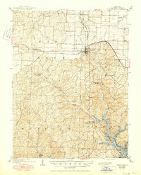
Versailles serves as the primary rail hub on this 1904 survey, where the St. Louis Kansas City and Colorado R. R. intersects with the Missouri Pacific R. R.. The landscape is defined by the complex drainage systems of the Haw Creek and Buffalo townships, featuring a notable concentration of geological landmarks and early industrial efforts. Mining activity is evident through the Juliette Mine in the north and the Buffalo Mine to the southwest. The karst topography of Morgan County is well-documented, showing several subterranean features such as Spears Cave, Jacobs Cave, and a Natural Bridge near the confluence of Brushy Creek and Gravois Creek. Settlements like Gravois Mills and the small post office at Lodema are connected by a network of early roads following the winding ridges and creek valleys.
Find a feature on this map
38 named features on this map. Tap any name to fly to it.
Don’t see what you’re looking for? This feature index may not catch every label — zoom into the map to look around manually.
Map Details
Editions of this 1904 Gravois Mills Map
2 editions found
Other maps of this area

1887 · Sedalia
USGS Topo · 1:125,000

1887 · Warsaw
USGS Topo · 1:125,000

1888 · Versailles
USGS Topo · 1:125,000

1888 · Boonville
USGS Topo · 1:125,000

1893 · Versailles
USGS Topo · 1:125,000

1894 · Warsaw
USGS Topo · 1:125,000

1894 · Sedalia
USGS Topo · 1:125,000

1904 · Eldon
USGS Topo · 1:62,500

1932 · Versailles No 4
USGS Topo · 1:48,000

1934 · Purvis
USGS Topo · 1:24,000