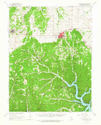
1961 Map of Gravois Mills
USGS Topo · Published 1965About this map
Versailles and Stover anchor the northern landscape of this Missouri Ozarks survey, where the rolling hills of Haw Creek and Moreau meet a deeply dissected river system. The geography is defined by the expansive fingers of the Gravois Arm of the Lake of the Ozarks, a major man-made water body that has reshaped the local economy around recreational landmarks like the Rolling Hills Country Club and Johnsons Bay.
Find a feature on this map
75 named features on this map. Tap any name to fly to it.
Don’t see what you’re looking for? This feature index may not catch every label — zoom into the map to look around manually.
Map Details
Editions of this 1961 Gravois Mills Map
This is the sole edition of this map. No revisions or reprints were ever made.
Other maps of this area

1887 · Sedalia
USGS Topo · 1:125,000

1887 · Warsaw
USGS Topo · 1:125,000

1888 · Versailles
USGS Topo · 1:125,000

1888 · Boonville
USGS Topo · 1:125,000

1893 · Versailles
USGS Topo · 1:125,000

1894 · Warsaw
USGS Topo · 1:125,000

1894 · Sedalia
USGS Topo · 1:125,000

1904 · Eldon
USGS Topo · 1:62,500

1904 · Gravois Mills
USGS Topo · 1:62,500

1932 · Versailles No 4
USGS Topo · 1:48,000